
Check our Events page for information on the kayak tours occuring August 20th!
New Report on the Exeter River Study (PDF Format)
State of the River update 2009 (PDF Format)
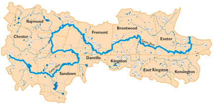
EXETER RIVER WATERSHED
The Exeter River rises from a group of spring-fed ponds in Chester, New Hampshire and flows 33 miles to downtown Exeter where it changes its name to the Squamscott River, and becomes a tidal river and a primary tributary to Great Bay.The river often meanders, frequently doubling back on itself, and passes through several short stretches of rapids in Brentwood before falling over the dam in Exeter. The Exeter River watershed covers an area of approximately 67,700 acres in Rockingham County.The watershed includes sizeable portions of ten municipalities, including Chester, Sandown, Danville, Fremont, Raymond, Brentwood, East Kingston, Kingston, Kensington, and Exeter.WHAT IS A WATERSHED?
A watershed consists of the land area that contributes water to a body of water or watercourse. All of the water that falls into a watershed runs to the lowest point – a stream, river, or lake. On its way, water travels over the surface and across forestland, fields, farms, lawns and streets, or it seeps into the soil and travels as groundwater. The Exeter River watershed features a number of tributary streams, all contributing to the river’s water quality and quantity.WATERSHED FACTS
Watershed Area – 67,700 acres (fresh water portion)
River Length – 33 miles
Drainage Basin – 126 square miles
Highest Elevation – 649 feet (Raymond)Land Use
Forested Land – 67%
Developed Land – 16%
Farmland – 6%
Water and Barren Land – 6%
Wetlands – 3%Projected Population
2020: 331,181Rockingham County
U.S. Census Population
1960: 98, 065
1980: 190,345
2000: 277, 359

Artwork by Cathy Arakelian and JoAnne Trahan
Website by Cricket Press

Web hosting generously donated by Hurricane Electric